In this issue:
Atitlán, or "place of the waters" in Nahuatl, is a lake in south western Guatemala, considered one of the most beautiful lakes in the world. Called Choi Lake by the modern day Maya-Cackchiquel people it actually is the result of a huge explosion 85,000 years ago, and the crater of a huge extinct volcano, lying some 330 metres below the surface. Itself it is nestled between three more sleepy volcanoes which you can hike with a guide for majestic views: Atitlán or Junc'at at 3,537m on the south of the lake, Toliman/Oxigahol and San Pedro/Nimajuyu. The Lake has an average diameter of 24 kilometers and a peculiar thing about it is that it has no visible outlet, the water finding somehow its way to the Pacific Ocean. The climate is mild, semi tropical and encourages agricultural pursuits. The lake has a pleasant temperature for the greater part of the year. The legend has it that once you swallow a drop of water from the lake you will return. The Tzutuhil people settled
on the south border of the lake by the year 1250 AC The ruins of Chuitinamit,
the ancient kingdom's capital city, can be seen near Santiago Atitlán. The
Quiche and Kackchiquel peoples were allies until 1470, when a bloody war
broke between them, and caused the Kackchiquel to become to become allies
with the Spaniards in 1523 and to defeat the Tzutuhils. The Spanish set up a
church and monastery in Panajachel soon afterward, and used the town as a
center for converting the Indians of the region to the Catholic faith. The
original façade of the church stills stands, and is one of the gems of the
colonial style in Guatemala. On a happier note, lake Atitlán is one of the most popular tourist attractions in Guatemala both for domestic and international visitors, being just three hours away from Guatemala City and a few km south of the Pan-American highway. Since the 1960s, hippies have discovered it and some have stayed on creating a small "scene" in one of the villages, Panajachel, which is the exception as it is rather commercialised. The placement of the
villages around the lake and
their names reflect the deeply mystical nature of the native population; Santiago
Atitlán, the pass to the Pacific Coast, is the capital of the Tzutujil Maya Nation and
considered by them the
Belly button of the Universe. It is all
set up as a visual representation of the world as the Maya knew it: the
world was set up on the axis of the tree of life, splitting space and time. The
villages were positioned on
the special cardinal points, starting with Santiago Atitlán and proceeding towards
Cerro de Oro and on around the lake. The circle followed the old calendar: 18 months of 20 days each.
The lake today is surrounded by fourteen villages, of which twelve are named
after the apostles, according to the Saints day that corresponds with the
date that fits with where the town is. Traditions have
fused, like the worship of Since 1955 the Atitlán basin has been declared a national park but this has not halted development and construction of summer residences and hotels has picked up in recent years as peace returned. Environmental mistakes have been made in the recent past such as the introduction of black bass to the lake in an attempt to attract and build a sport-fishing industry. Predictably the bass ate the small fish and speeded up the extinction of the Atitlán grebe, a flightless bird, and the death of the fishing industry in some of the villages that ring the lake. As a response under the Parks in Peril program, The Nature Conservancy has partnered with local nongovernmental organizations (NGOs) to improve protection and biodiversity in the Atitlán basin. When in Atitlán, you can stay at
Eco-Hotel Uxlabil
an Ecolodge Member of ECOCLUB.com, a private effort of Mr. Fransico Sandoval
to support the well-being of local people and conservation. Uxlabil pledges
to operate in close and harmonious cooperation with
nature and with the people of the San Juan village.
The restaurant is managed by two indigenous families who receive 85% of
the income. You will be provided with a map identifying the most
important weavers, painters and coffee growers, healers even and they will
arrange for you to visit them at their
homes, workshops and farms. Uxlabil do not sell local products, they only exhibit them and encourage
guests to buy them directly from the producers. Uxlabil is also a member of
the "Asociación de Amigos del Lago de Atitlán" a non-profit NGO,
and actively involved in the local community as a member of the water
committee, the electricity committee, the soccer club, the weavers
association and of the local public school board.
Of volcanic origin and just 47km long and 26 km wide, Dominica is arguably the most mountainous Caribbean Island and one of the lushest, featuring the highest mountains in the Eastern Caribbean, from which more than 200 rivers run down to the sea, through rugged valleys, not yet eroded (at just 26 million years old the youngest island in the Caribbean!), producing magnificent waterfalls and sometimes less magnificent flash floods. Morne Trois Pitons "mountain of three peaks" dominates the island at 1300 m., the three peaks being basaltic spike-like remains of a former volcano. In 1998 it was declared an Unesco World Heritage site, only one of two in the whole Caribbean. It encompasses five major mountains (Morne Micotrin, Morne Nicholls, Morne Watt, Morne Anglais, and Morne Trois Pitons after which the park is named), the Valley of desolation with fumaroles, hot springs, mud pots and sulphur vents, the world-famous Boiling Lake, second-largest of its kind in the world, the aptly named Stinking Hole (a lave tube in the middle of the forest), Boeri Lake (in the crater of an extinct volcano), along with Fresh Water Lake, the Emerald Pool, several waterfalls, and tracts of relatively undisturbed rainforest and montane vegetation. Development of a mass tourism industry was fortunately difficult because of the rugged coastline, lack of beaches, and the lack of an international airport and thus Dominica has been focusing on nature tourism since the 1970s. Dominica is well known for its vast rainforests (67% of total land), but the island also has montane thickets, dry scrub woodlands, evergreen forests, fumarole vegetation, cloud forests and elfin woodlands. The most abundant tree on the island is the gommier, a huge gum tree that's traditionally been used to make dugout canoes. The most colorful of Dominica's endemic plants is its national flower, the bwa kwaib, or Carib tree. A deciduous shrub, it's found on the island's drier west coast. In spring, the bare branches of this shrub suddenly become thick with hundreds of scarlet flowers, adding a bright splash to the countryside. In January the average high temperature is 85°F (29°C) while the low averages 68°F (20°C). In July the average high is 90°F (32°C) while the low averages 72°F (22°C). The driest months are February to June. All these statistics are for Roseau - the mountains are cooler and wetter.
Dominica is fortunate that the majority of visitors to the island are primarily attracted by the island's wealth of natural resources and its reasonably sound environmental policies. Government policy focuses on both cruise and stay-over tourism. Their ultimate goal is to convert a percentage of those visiting as cruise passenger into returning as stay-over visitors. Currently, Dominica receives approximately 250,000 cruise and 75,000 stay-over visitors annually. Our Ecolodge Members Hibiscus Valley Inn have recently had some success in doing just that, converting that is cruise visitors into ecotourists. Hibiscus offer three lovely wooden bungalows in typical Dominican Carib style, in a peaceful setting overlooking a river at the edge of the rainforest. For more details on
Dominica and Hibiscus Valley Inn please visit http://ecoclub.com/hibiscus Copyright © 1999-2002 ECOCLUB
S.A. All Rights Reserved. |

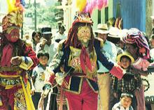 The
picture is from a celebration of the feast day of San Pedro the patron saint
of San Pedro La Laguna, one of the indigenous villages on the lake. The
ceremony is known as the dance of the conquest and the red haired Spaniard
center stage represents Pedro de Alvarado, Cortez's man sent to conquer the
lands south of Mexico. The dance represents the last stand by the native
peoples led by Tecun Uman, to withstand the Spaniards. In more recent
memory, the local population of the Lake had to endure the the longest civil
war (35 years) in the Americas that cost 100,000 lives and displaced half a
million people. Santiago Atitlán was the first village in Guatemala to
demand and achieve the expulsion of the army from the village in 1991
following an army atrocity, and they set the example for other villages, as
in the old times.
The
picture is from a celebration of the feast day of San Pedro the patron saint
of San Pedro La Laguna, one of the indigenous villages on the lake. The
ceremony is known as the dance of the conquest and the red haired Spaniard
center stage represents Pedro de Alvarado, Cortez's man sent to conquer the
lands south of Mexico. The dance represents the last stand by the native
peoples led by Tecun Uman, to withstand the Spaniards. In more recent
memory, the local population of the Lake had to endure the the longest civil
war (35 years) in the Americas that cost 100,000 lives and displaced half a
million people. Santiago Atitlán was the first village in Guatemala to
demand and achieve the expulsion of the army from the village in 1991
following an army atrocity, and they set the example for other villages, as
in the old times. Maximon
part Mayan part Catholic. The colourful striped clothing that to the eye of
the tourist is so Mayan, is also a fusion: the Spanish imposed the
different coloured stripes on the different villages as a way of distinguishing
and controlling them. To this day most villages keep to those colours but
have added their own patterns.
Maximon
part Mayan part Catholic. The colourful striped clothing that to the eye of
the tourist is so Mayan, is also a fusion: the Spanish imposed the
different coloured stripes on the different villages as a way of distinguishing
and controlling them. To this day most villages keep to those colours but
have added their own patterns.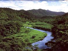 It
was November 3 1493, it was a peaceful Sunday, it was a beautiful rugged
island, and Columbus naturally called this beautiful Dominica. Nevertheless,
Dominica was the last of the Caribbean islands to be colonised by Europeans,
due to its ruggedness and the proud resistance of the native Caribs. France
ceded possession to Great Britain in 1763, which made the island a colony in
1805. A mere 175 years later, in 1980, Dominica's fortunes improved when
Mary Eugenia Charles became the first female prime minister in the Caribbean
and remained in office for 15 years.
It
was November 3 1493, it was a peaceful Sunday, it was a beautiful rugged
island, and Columbus naturally called this beautiful Dominica. Nevertheless,
Dominica was the last of the Caribbean islands to be colonised by Europeans,
due to its ruggedness and the proud resistance of the native Caribs. France
ceded possession to Great Britain in 1763, which made the island a colony in
1805. A mere 175 years later, in 1980, Dominica's fortunes improved when
Mary Eugenia Charles became the first female prime minister in the Caribbean
and remained in office for 15 years.  A
fascinating characteristic of Dominica is that it is the only Caribbean
island where the native Caribs have survived. 3000 descendants of the Carib
Indians, the regions first settlers, continue to live in the traditional way
in the islands north-east, practising their time-honored crafts of canoe
building and basket weaving, little changed since 1493, despite centuries of
abuse. They live in eight villages on the East Coast of Dominica
collectively called the Carib Territory. The Caribs have their own chief and
also a representative in the house of assembly. They tend to keep to
themselves and their culture has remained very much unchanged. They
reputedly use 300 different herbs for medicine -- some of the best bush
doctors hail from the Territory. Dances, traditions, legends, and beliefs
have been kept alive by the elders who pass on theses traditions through
Story-Telling. Their language is unfortunately only spoken by a few people
today but their dances are being performed by Karifauna, their dance group.
A
fascinating characteristic of Dominica is that it is the only Caribbean
island where the native Caribs have survived. 3000 descendants of the Carib
Indians, the regions first settlers, continue to live in the traditional way
in the islands north-east, practising their time-honored crafts of canoe
building and basket weaving, little changed since 1493, despite centuries of
abuse. They live in eight villages on the East Coast of Dominica
collectively called the Carib Territory. The Caribs have their own chief and
also a representative in the house of assembly. They tend to keep to
themselves and their culture has remained very much unchanged. They
reputedly use 300 different herbs for medicine -- some of the best bush
doctors hail from the Territory. Dances, traditions, legends, and beliefs
have been kept alive by the elders who pass on theses traditions through
Story-Telling. Their language is unfortunately only spoken by a few people
today but their dances are being performed by Karifauna, their dance group. Dominica's
wildlife includes: Bats, the only known indigenous mammals. - The Agouti, a
large guinea-pig-like rodent and the Manicou (an opossum) introduced
hundreds of years ago. - Boa Constrictors and a few other harmless species
of snakes, various lizards, and tree frogs. The largest frog is the mountain
frog, also known as "mountain chicken" denoting that it is a very
popular delicacy. - The most spectacular insects are the Hercules beetle and
the almost invisible, camouflaged stick insect, or Chouval Bwa.- There are
166 species of birds in Dominica, including two endemic and endangered
species of parrot, one of which, the Sisserou (Amazona imperialis) adorns
the country's flag. After thousands of years on this island, the Sisserou
found itself on the brink of extinction in 1976 when a breed and release
program was initiated. Whale watching is excellent,
especially from November through March whales migrate through or hang out around
Dominica, thanks to her deep waters (6,000 ft). You can see up to
seven species of whales (orca, pilot, sperm, cow, humpback,
spinner and false killer whales) and eleven types of dolphins.
Dominica's
wildlife includes: Bats, the only known indigenous mammals. - The Agouti, a
large guinea-pig-like rodent and the Manicou (an opossum) introduced
hundreds of years ago. - Boa Constrictors and a few other harmless species
of snakes, various lizards, and tree frogs. The largest frog is the mountain
frog, also known as "mountain chicken" denoting that it is a very
popular delicacy. - The most spectacular insects are the Hercules beetle and
the almost invisible, camouflaged stick insect, or Chouval Bwa.- There are
166 species of birds in Dominica, including two endemic and endangered
species of parrot, one of which, the Sisserou (Amazona imperialis) adorns
the country's flag. After thousands of years on this island, the Sisserou
found itself on the brink of extinction in 1976 when a breed and release
program was initiated. Whale watching is excellent,
especially from November through March whales migrate through or hang out around
Dominica, thanks to her deep waters (6,000 ft). You can see up to
seven species of whales (orca, pilot, sperm, cow, humpback,
spinner and false killer whales) and eleven types of dolphins.